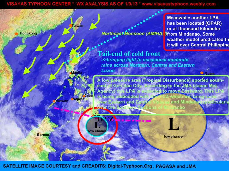
Cebu, PHILIPPINES- The low pressure area (tropical disturbance) which has been out the PAR yesterday, has entered again the PAR and spotted at 150km SE of General Santos City. According to the 24 hr. forecast track of Japan Meteorological Agency, this system will move eastward. The LPA also is embedded along the Inter tropical Convergence Zone [ITCZ] which bring rains across Visayas and Mindanao specially on the southern portions. Going also to the north (LUZON) there is also tail-end of cold front and the NE monsoon affecting to it so expect light to occasional moderate rains.
On the other hand there was also a tropical disturbance outside of PAR (about 1,190 km east of Mindanao), this LPA is expected to enter the PAR tomorrow afternoon or evening, there is also a chance that this LPA will be dissipate.
CEBU, Philippines - The tropical disturbance that has been monitored yesterday by PAGASA, has enter the Philippine Area of Responsibility, Saturday afternoon. According to the NOAA (a weather portal in USA), the system packed a winds up to 28kph. It's central pressure is estimated to be at 1010 mb, they also located the LPA at 4°N, 136.5°N; meanwhile the PAGASA located it at 6°N, 136°E. The said disturbance is embedded along the Intertropical Convergence Zone that bring rains across the Mindanao and Central visayas. Going also to the north, light to occasional rains shall be expected due to the Northeast Monsoon (Amihan)
VISAYAS TYPHOON CENTER '94W' Probability of becoming a tropical depression: 35% (LOW)
RAINSTORM WARNING #1 (heavy rains will be expected within 12 to 24hrs.)
MINDANAO: Compostela Valley, Davao Oriental and Samal Island
[Note: Do not use this warning in life decision, Kindly refer to PAGASA for the official weather warning]
A tropical disturbance (known as LPA) has been spotted southeast of Mindanao. According to the latest weather bulletin of PAGASA, the LPA has been located at 1,020km Southeast of Mindanao with a coordinates of 5.0°N, 136.0°E. They also forecast that the system is embedded along with the ITCZ which bring light to moderate rains across the Leyte Provinces and Mindanao.
Latest Japan Weather Bureau (Japan Meteorological Agency) has upgraded the system into a tropical depression., Meanwhile the US Navy (JTWC) didn't issue any warning in this system.
Here are the possibilities which can possibly develop the disturbance into a tropical depression:
> relatively warm sea surface temperature (over the WesPac)
> decreasing wind shear
> good low level convergence coupled with high level divergence exists over the area.

 RSS Feed